Shopping lakefront around Lake Blue Ridge and seeing phrases like “deep water,” “year‑round water,” or “quiet cove”? It is easy to assume these terms all mean the same thing from one listing to the next, but they often do not. If you want the right dock, boat access, and shoreline experience, it pays to understand the language. In this guide, you will learn what each term means, how it is used in Fannin County, and how to verify claims before you fall in love with a property. Let’s dive in.
Deep water explained
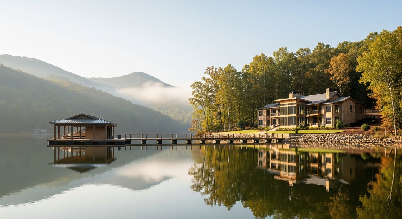
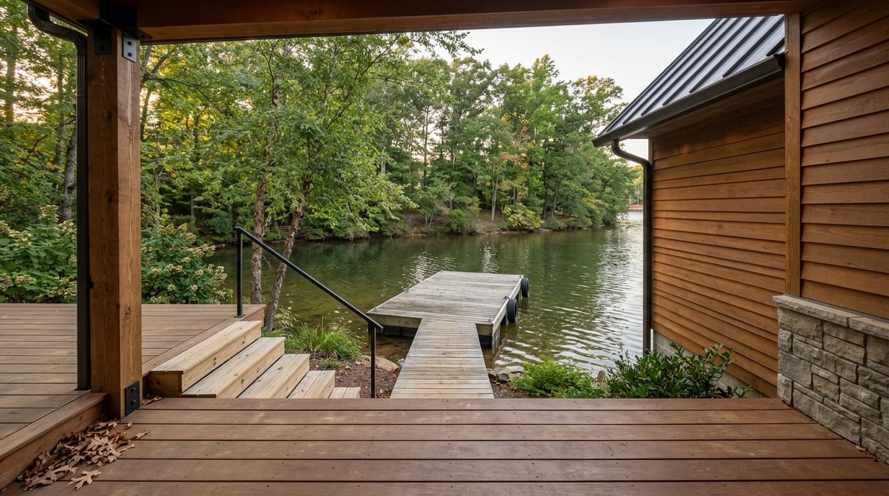
“Deep water” usually means the water by the dock or shoreline is deep enough for motorboats to approach and stay afloat through normal seasonal changes. Agents use it as shorthand for powerboat-friendly access, including pontoons and runabouts.
On Lake Blue Ridge, water level can change because it is a reservoir. What one listing calls “deep” may not be deep enough for larger boats or for low-water periods. If you want reliable boat access and fewer dock adjustments, you need specifics.
What to verify
- Ask for depth at the dock at normal pool and at typical seasonal low.
- Request a bathymetry map, recent depth soundings, or a dock inspection video.
- Confirm whether the dock is floating and if it has a lift that helps in marginal depths.
Year‑round water vs. seasonal drawdown
“Year‑round water” means the shoreline or dock site stays wet throughout the year instead of becoming exposed during routine drawdowns. Listings use it to signal continuous access for boating outside of unusual events.
Because Lake Blue Ridge is managed as a reservoir, drawdowns can occur for maintenance, flood control, or power operations. Year‑round claims should match the lake’s operating patterns and the specific cove or inlet where the home sits.
What to verify
- Ask for the normal pool elevation and any typical drawdown schedule for Lake Blue Ridge.
- Confirm whether the property’s cove or inlet has a history of shoaling or stranding docks during low water.
- Check with county or marina contacts to see if the dock location has experienced exposed lakebed in recent years.
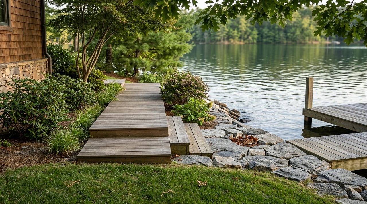
Cove vs. main channel
A main channel location sits on the lake’s primary navigable corridor. A cove is a smaller inlet off the main water. Listings often say “on the main channel” to suggest deeper water and easy navigation, while “quiet cove” suggests calmer conditions and more privacy.
Both can be great, but they feel different.
- Main channel: faster access to open water and marinas, often deeper, with more boat traffic and more wake.
- Cove: quieter and often better for swimming, but entrances can be shallower and may require careful navigation at lower water.
What to verify
- Review satellite or bathymetry maps to gauge the cove mouth depth and width.
- Ask whether the cove entrance is navigable during typical low‑water periods.
- Clarify noise and sight lines to the main channel so you know what to expect on busy weekends.
Wake zones and speed rules
Wake zones are areas with posted speed limits, often no‑wake, to protect shorelines, docks, and swimmers. Listings may say “no‑wake cove” or “protected from heavy wakes” to highlight calmer water.
On Lake Blue Ridge, rules can be posted by local authorities, and statewide boating laws apply. Definitions and enforcement can vary by lake segment, so you should verify any claim rather than rely on a listing note.
What to verify
- Check with Fannin County officials or local marina management about posted wake and no‑wake areas.
- Ask the sheriff or boat patrol about typical enforcement and problem zones.
- Look for photos or signage showing slow/no‑wake buoys near the property.
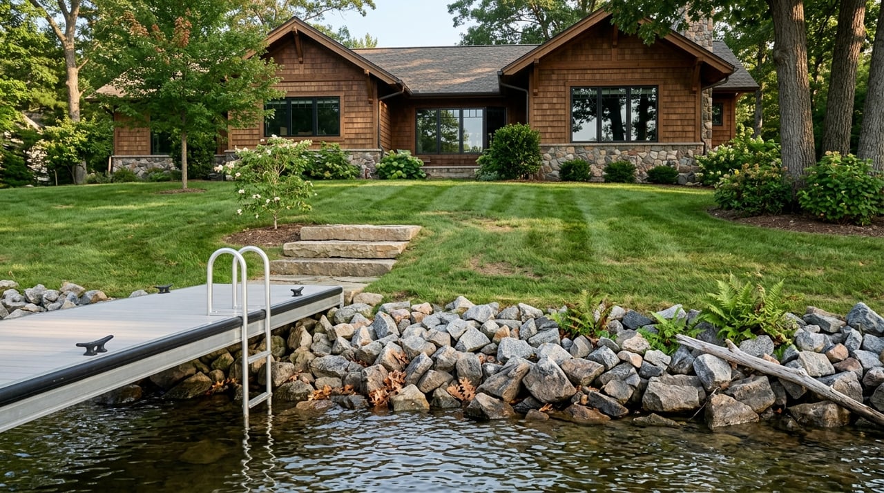
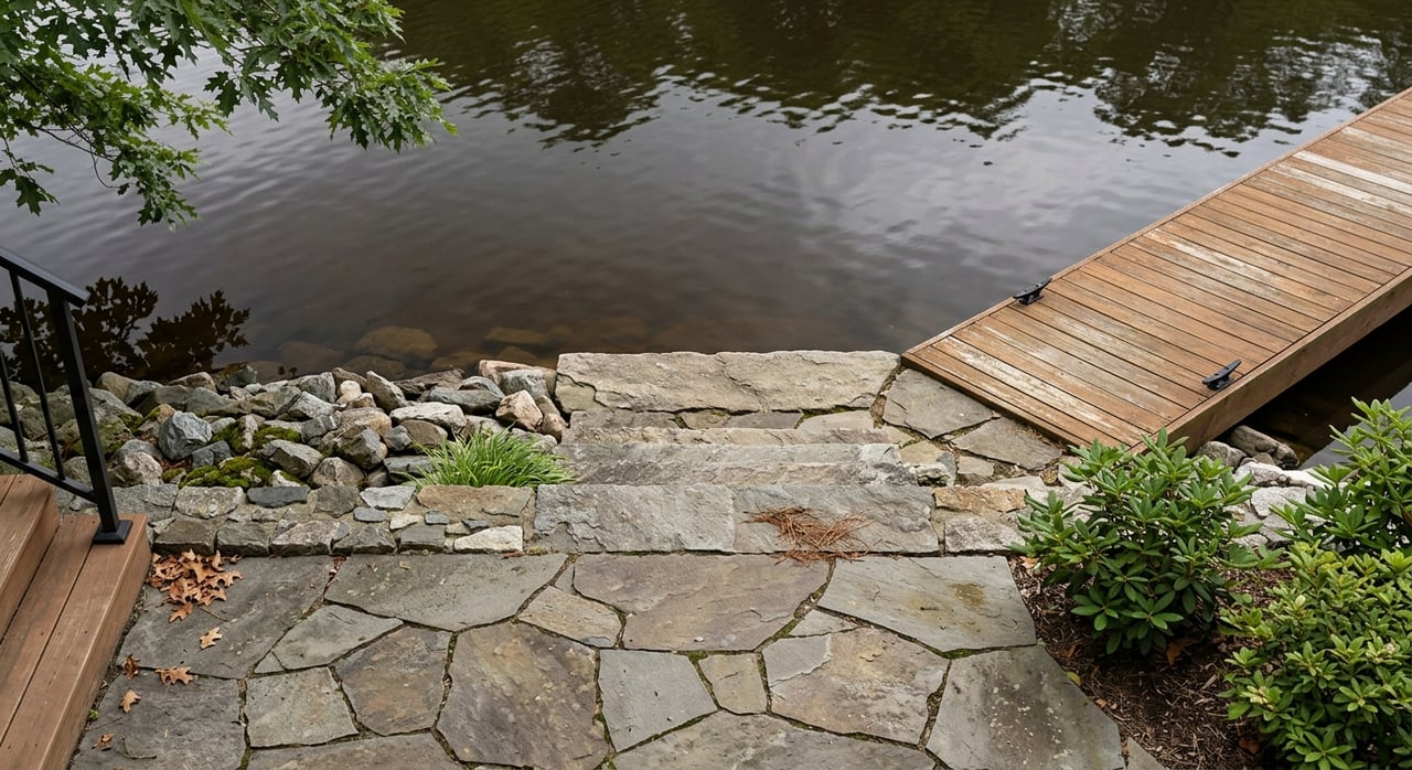
Shoreline contour and material
A shoreline’s contour and material affect daily enjoyment, erosion risk, and dock construction. Listings often use terms like gradual slope, steep drop‑off, rocky shore, riprap, or bulkhead.
- Gradual slope: easier walk‑in swim access and potential beach use, but more maintenance and higher erosion risk.
- Steep drop‑off: deep water close to shore, which is convenient for docks, but can limit space for play areas.
- Rocky or riprap: helps control erosion and can stabilize banks, but may limit natural shoreline use and require permits for changes.
What to verify
- Request recent shoreline photos from multiple angles and seasons. Drone or satellite images help confirm the true contour.
- Ask whether any erosion control, riprap, or bulkhead work was permitted and when.
- Confirm septic location, floodplain boundaries, and setbacks relative to the shoreline.
Permits, rights, and risks to review
With waterfront, details matter. You want to confirm what exists, what is allowed, and what can be transferred to you at closing.
- Permitting: Permanent shoreline work, boathouses, or significant riprap often require approvals. Confirm with Fannin County Planning and Permitting and with Georgia Department of Natural Resources for state-level requirements.
- Replacement vs. new: Older docks may be grandfathered. Replacing or enlarging them can trigger current standards.
- Riparian rights: Waterfront owners typically have rights to reasonable access and dock placement, but submerged lands and navigation are often state-owned. Verify exact rights with the listing agent and your title company.
- Shared docks and covenants: Read HOA or shared-dock agreements for maintenance duties, boat-size limits, and use rules.
- Insurance and safety: Shoreline type and flood exposure influence homeowner’s and flood insurance. Get quotes early.
- Environmental and septic: Steep slopes and local soils can affect septic permitting. Counties restrict systems near the water.
Quick buyer checklist
Use this checklist when you compare Lake Blue Ridge listings online.
Documents and data to request
- Recent survey showing property lines to the water, dock placement, and any easements.
- Dock or boathouse permits and any proof of grandfathered structures.
- Historical water-level information or the operator’s drawdown schedule for Lake Blue Ridge.
- Bathymetry map or recent depth readings by the dock and at the cove entrance.
- HOA rules, slip agreements, and covenants that affect boating or shoreline use.
- Photos or video showing the dock during different seasons, including low water.
On‑site observations
- Walk the full shoreline to look for shallow shoals, underwater hazards, and erosion.
- Inspect the dock for anchoring, wear, and compatibility with your boat and lift.
- Talk to neighbors and local marina staff about typical depths, seasonal changes, and wake behavior.
Questions to ask the seller or agent
- Is the dock usable at typical low‑water levels? What are the latest depth readings at the dock and at the cove entrance?
- Has the lakebed near the dock been exposed during drawdowns? When and for how long?
- Are there posted no‑wake or speed limits near this lot? Any private agreements that restrict wakes or boat types?
- Are there any recorded easements that grant others dock or access rights in this cove?
- Who issued the dock or shoreline permits, and can they be transferred or reissued to a new owner?
Tools you can use at home
- Satellite imagery to verify cove shape, dock placement, and nearby traffic routes.
- Bathymetric charts or depth info from local marinas to identify safe paths.
- County GIS maps for parcel lines, floodplain layers, and possible easements.
How a local advisor helps
Waterfront language is short, but your decision is big. A seasoned, local guide will help you confirm depth, dock viability, and shoreline rules before you make an offer. With two decades of lake and mountain experience across North Georgia and Western North Carolina, Karyn helps you align the lifestyle you want with the property that can deliver it.
If you are ready to compare Lake Blue Ridge options with clear criteria and a plan, connect with Karyn Woody. You will get local insight, steady guidance, and a process designed for second‑home buyers and retirees.
FAQs
What does “deep water” mean on Lake Blue Ridge?
- It usually means water by the dock is deep enough for motorboats through normal seasonal changes, but you should ask for exact depth at normal pool and seasonal low.
How do I confirm “year‑round water” on a listing near Blue Ridge?
- Request normal pool and typical drawdown info, ask for depth readings in the cove, and verify with local marina contacts if docks stay afloat off season.
Is a main channel location better than a cove on Lake Blue Ridge?
- Main channel spots offer faster access and often deeper water, while coves tend to be quieter; choose based on your boating, swimming, and privacy needs.
How can I check wake or no‑wake zones near a property?
- Confirm with Fannin County or local marina management, look for posted buoys in photos, and ask boat patrol about typical enforcement in that area.
What shoreline types are best for swimming and docking?
- Gradual slopes help with swim access and beach feel, while steep drop‑offs give deep water close to shore for docking; match the shoreline to how you plan to use it.
Do I need permits for dock or shoreline changes in Fannin County?
- Most permanent work and dock changes require approvals; check with Fannin County Planning and Permitting and Georgia DNR before planning modifications.